|
Brisbane's Most Damaging Ever Thunderstorm - January 18, 1985
The afternoon of Friday the 18th of January, 1985 is remembered by many Brisbane residents as the worst storm they had ever experienced. At the time, it was the second most damaging natural disaster (to the 1974 floods) in the history of Queensland. In terms of destructive thunderstorms in SE Qld this storm came first, and daylight second.
It was a typical Brisbane Summer day, with hot and sultry NW/NE winds. Brisbane residents were bearing up to the heat in anticipation of a cooling thunderstorm ahead of a fresh SE wind change. And that's exactly what happened, but nobody thought the storm would be so severe. A coastal front had slowed and was in the Coolangatta area, and a trough was located over the inland, but ominously, a cold pool of air lay in the upper levels to the SW of Brisbane.
During the early afternoon, storms developed as they frequently do in Summer on the Border Ranges, to the South and SSW of Brisbane. From 2:30pm one particular storm became organised, and by 3:20pm a severe thunderstorm was reported at Mt Alford, SSW of Boonah. That was the start of Brisbane's most damaging ever thunderstorm.
By 4pm, the thunderstorm had assumed massive proportions with cloudtops at 18km and there was a large area of maximum reflectivity - indicative of hail. It was located just east of Harrisville south of Ipswich at this time, and destructive winds and large hail were being reported. At 4:20pm, with the Goodna area in the far SW Brisbane suburbs being affected, cloudtops suddenly fell to around 16km, but nevertheless, the storm was as severe as ever. The storm started intensifying again, so that at 4:50pm the cloudtops were nearing 17km as it approached Brisbane's CBD from the SSW.
With workers starting to drive home with a weekend in front of them, it hit. Suburbs including Oxley, Kenmore, Toowong, Chermside, Hendra, Nundah and Sandgate were hit particularly hard. At the Regional Office of the Brisbane Bureau of Meteorology in the CBD a record wind gust of 145km/h (78kn) was recorded, and then one of the most extreme officially recorded wind gusts in the history of Australian storms struck: 185km/h (100kn) at the Brisbane Airport. That's close to a 193km/h recorded gust at Tennant Creek in the 1960's. The winds blew hailstones of up to 7cm in diameter almost horizontal resulting in infinite smashed windows. Many residents resorted to hiding under tables and mattresses as the giant hailstones smashed through the windows and ferocious winds blew off roofs.
At Toombul, damage was severe. A man whose apartment block had been completely unroofed said: "The sound was amazing. There were bits of corrugated iron and guttering flying though the air and crashing up against the two buildings".
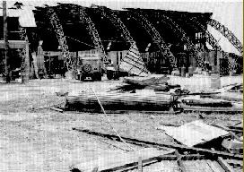
At the Brisbane Airport, where the extreme wind gust was recorded, 12 pre-fabricated site office sheds were blown and rolled at least a distance of 100m then damaged severely.
It was estimated that 20% of the vehicles in the city were hail damaged, over 20 000 buildings damaged and 80 000 premises were blacked out. The Wool Store furniture centre in Newfarm had 2500 broken windows on the windward side of the building, their damage bill being $5 million. Amazingly, the store had survived every storm undamaged since 1927.
The rainfall intensities that came with the storm were particularly high. Between 60 and 70mm were reported from SW suburbs, the inner City and some N and NE suburbs. At the Eagle Farm Airport, a 15 min intensity of 57mm was recorded - that's a rate of 228mm/hour. At Clayfield, a family were caught in their home when the local creek rapidly rose. They were luckily able to get out when the water was up to their shoulders.
This supercell thunderstorm seemed to have followed the Brisbane River, before moving just north of it. Roughly, the damage path of the storm was about 10km wide. The northern suburbs badly damaged included Banyo, Wavell Heights, Chermside, Clayfield, Windsor, Hendra, Ascot, Hamilton, Northgate and Nundah. Many residents in these suburbs were injured. To this day, this storm that hit Brisbane at 5pm on a Friday afternoon remains our worst ever. There have been other major storms, like those of 4/11/73, 16/12/80, 24/12/89 and 29/1/95 but they don't compare to that of 18/1/85. Of course it is inevitable that a more severe thunderstorm possibly with tornadic activity will strike the city, but residents are hoping that their luck will prevail.
|
|