|
Nudgee Waterholes were a home and food gathering area to many generations of Aborigines, even after European arrival. The waterhole is fed by a permanent spring near Red Hill Road and runs under Redway Street into an open brook which flows into the waterhole. From there it runs under Nudgee Rd and into the Kedron Brook Floodway.
The Aboriginal management of the waterhole was a credit to them. The water was very clean, free of foreign weed growth, full of fish, turtles, water fowl and other fauna food sources.
The men's Bora Ring (Heritage Location 33) is still adjacent to the waterhole. There are no remains of the women's camp and Bora Ring which was believed to have been close to Red Hill Road near the spring which fed the Nudgee waterhole.
The Aborigines of Nudgee and the very early settlers had a wonderful relationship. The settlers would share food with them and the Aborigines would in return provide mud crabs and fish which had been caught in the salt water creeks nearby. According to Aboriginal folklore, the Nudgee waterhole had never run dry and was always good water.
European settlers used the waterhole for permanent clean drinking water for themselves and their stock. Carts were used to carry water to the farms for the crops. Stock driven to the Brisbane markets would use the fresh drinking water and a cattle dip was built nearby.
In the early days pure clean sand from the waterhole area was used to make concrete for construction work on local farms. Large mullet could be seen jumping out of the water and could easily be caught after heavy rains as they crossed the causeway on the dray track (later to become Nudgee Road).
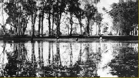
The waterholes for a while were a very popular picnic and camping area. In the 1920s and 30s, Gypsies often took up residence here. A kiosk was built on the Northern bank near the cattle dip which was constructed and operated by the Toombul Shire Council. The waterholes were excavated and deepened by the Council in 1919. A gravel quarry had previously been built to supply material for local roads. It was closed in 1919.
In the period of the early 1920s, the shire Alderman William Schulz would put a timber dingy into the water hole to clean out foreign weed growth. He would keep the picnic area clean as families from all over the north side of Brisbane would travel by car or horse and sulky to picnic by the clean waters of the reserve (which then looked like a lake).
Part of the reserve was used as a camp by the American Armed Forces in 1942, who left behind two large petrol dumps.
Since the war years, the sediments and nutrients from farming have caused the waterholes to silt up and be taken over by reeds, grasses and paperbark trees. In 2001, the Brisbane City Council restored part of the Waterholes to their former state.
Between Nudgee Road and the Gateway Arterial, adjacent to the Nudgee Waterholes Reserve is a small section of well established vegetation. This is the remnants of what was once known as Child's Scrub.
In 1886 the Childs Family established the nearby Toombul Vineyards. A very well patronised wine bar operated there until the early 1960s. In 1928, Bill Childs started work on what is now the Nudgee Golf Club. The Childs Family's water well is still visible, located not far from the golf clubhouse.
Nudgee Waterholes Rejuvenation
Bora Ring Uncovered
|
|